
The Penha de Águia hike is one of my favorite adventures on Madeira and I actually did it three times, hunting for the perfect sunrise. It’s a pretty steep climb to the top of the rock that sits in between the two towns of Faial and Porto da Cruz on the east coast of Madeira Island. Penha de Águia actually translates to the Eagle’s Nest, which the mountain does resemble from afar. A 400-meter climb to the top gives you stunning views over Porto da Cruz and all the way to São Lourenço, the most eastern tip of the island. The hike then crosses the top of the rock to finish by leading you down into Faial. It’s a little wild but offers amazing coastal views.
TOP 3 PLACES TO STAY IN MADEIRA
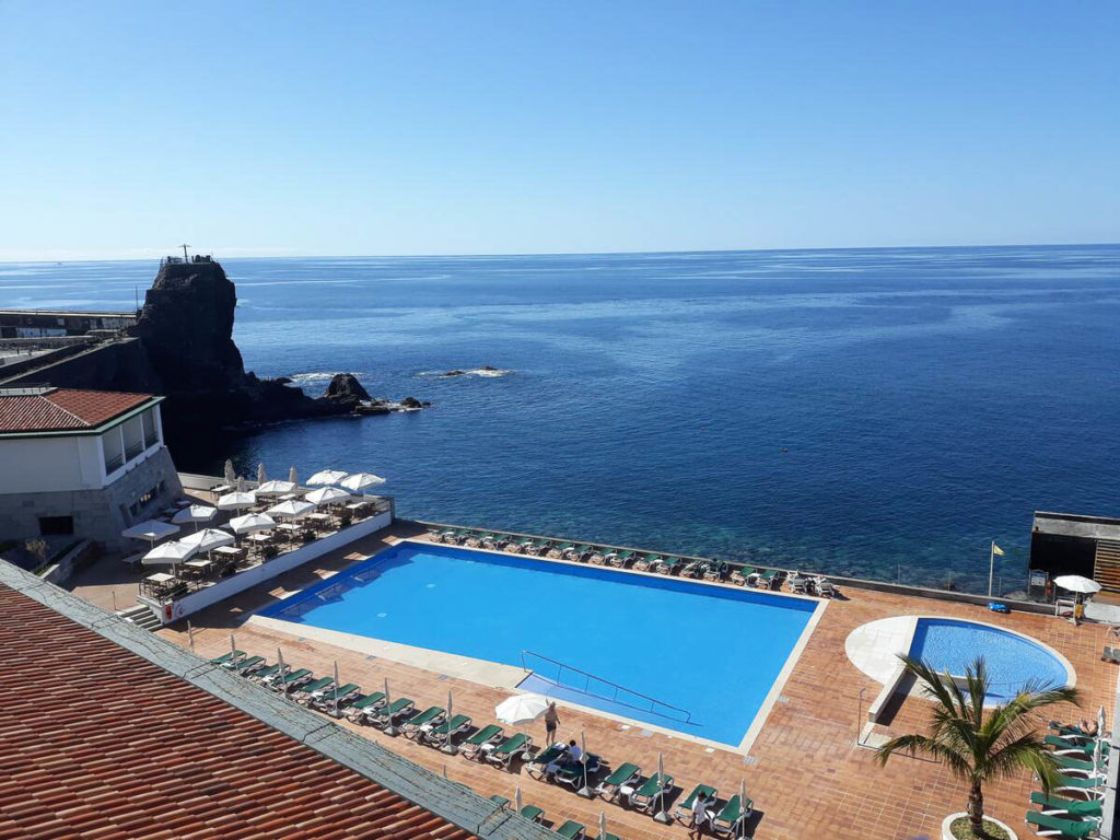
- Ultimate Luxury: Les Suites at Cliff Bay best location and view
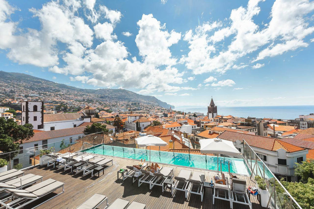
- Best Value: Hotel Alto Lido – Funchal rooftop swimming pool under 100 Euros
- Budget Hostel in Funchal: Santa Maria Hostel is easily the top hostel in Funchal
PENHA DE ÁGUIA HIKE DETAILS
There are a couple of options for the hike. You can either go straight up and down to the viewpoint on the Porto da Cruz side or you can go up, across the rock, and down into the Faial side. Once in Faial you can either walk back along the roads to complete the loop or catch a bus/uber. I tried the up and down option and walking back from Faial. In the details below, I will cover the walking back from Faial option because it is the most practical and common.
- Hike Distance: The total distance of the loop was 8 kilometers.
- Hike Duration: The hike will take you about 3 hours, especially if you have a break at the top viewpoint.
- Hike Difficulty: This trail is undeniably steep. I did the trail each time for sunrise, so this meant completing the ascent in the dark with a headlamp. The difficulty was therefore increased but still was manageable. On the ascent, you will have a muddy, slippery track. You will need to manage some rocks, tree roots, and uneven surfaces to reach the top of the rock. There is always a defined path but it can be overgrown and a bit wild. I’d say this is for more experienced hikers but it was nothing very dangerous. The only exposure to drop-offs you will find is when you are at the viewpoint. The rocks there can be slippery but there is no need to go near the edge except for a photo or by choice.
- My hiking guide: I did this hike with a local guide (also a great friend) called João. He’s lived in Madeira his whole life and knows all of the unique trails (not just the popular ones). This trail requires some local knowledge for the directions so I recommend a guide. Want to contact João to be your guide for this hike or any of the hikes I’ve done on Madeira? You can contact him on Instagram here: João Let’s Hike or by email: joaoletshike@gmail.com
- Hike Incline: Total incline for the hike was 686 meters including the incline from Faial back to the starting point.
- My Strava Map Upload: The Eagle’s Nest

HOW TO GET TO THE PENHA DE ÁGUIA HIKE
The trailhead is right next to Katrepa’s Bar, where we actually had a coffee one time after the hike. You can park on the street here and then take the road opposite the bar and head into the neighborhood. There is a small little alley that leads you along the levada and through a banana plantation for a few hundred meters until you see a wooden sign that says Penha de Águia on your left and leads you up the dirt path to the summit.


BEST RENTAL CAR COMPANY ON MADEIRA
When you book your Madeira Rental Car online, I personally recommend and always use Discover Cars. They search for both local and international companies, so you get the best deal! MUST Read: Guide to Renting a Car on Madeira
MY EXPERIENCE ON THE PENHA DE ÁGUIA HIKE
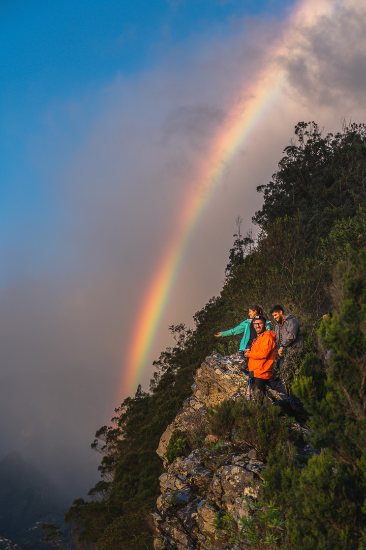
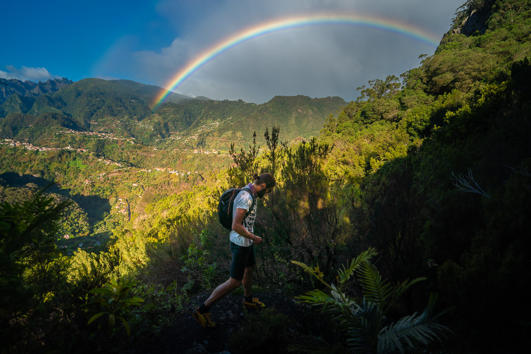
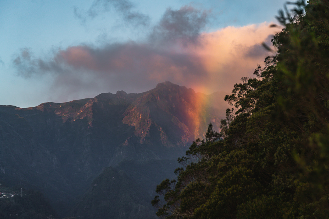
I actually started to obsess a little bit over this hike. The first time I went there was just a glimmer of sun but I loved the view so I vowed to come back. The second time I visited, there was no sun at all and then, on my birthday, I visited for a third time and there was a great sunrise and rainbows so my persistence paid off.
The hike begins through the small neighborhood, up an alley, and then alongside the levada until you veer off to the left and begin your ascent up the dirt track. I did this hike every single time before sunrise with a headlamp in the dark. The photos you see here of this early section of the hike are from the time I went to the Porto da Cruz summit side and descended down the same route rather than crossing the rock and descending to Faial. That’s why it is light rather than pitch black and also why we are walking down not up but it’s good to show you the route.


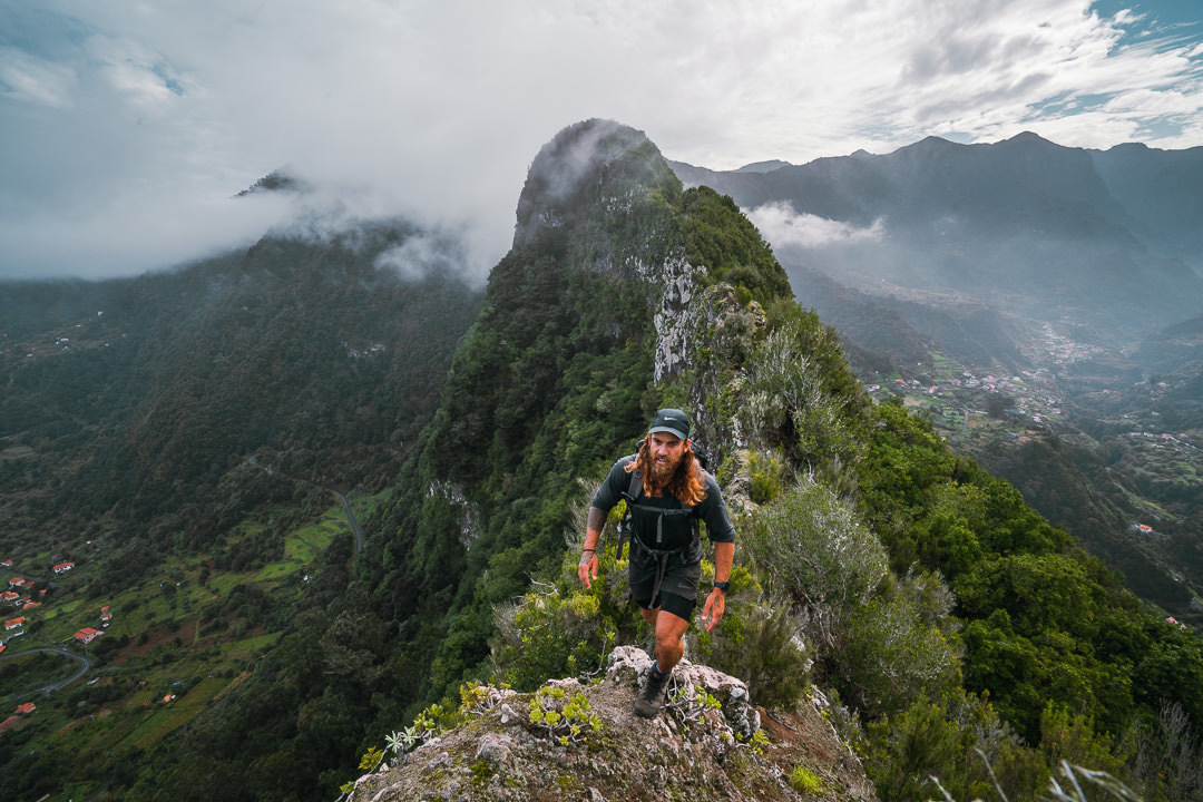
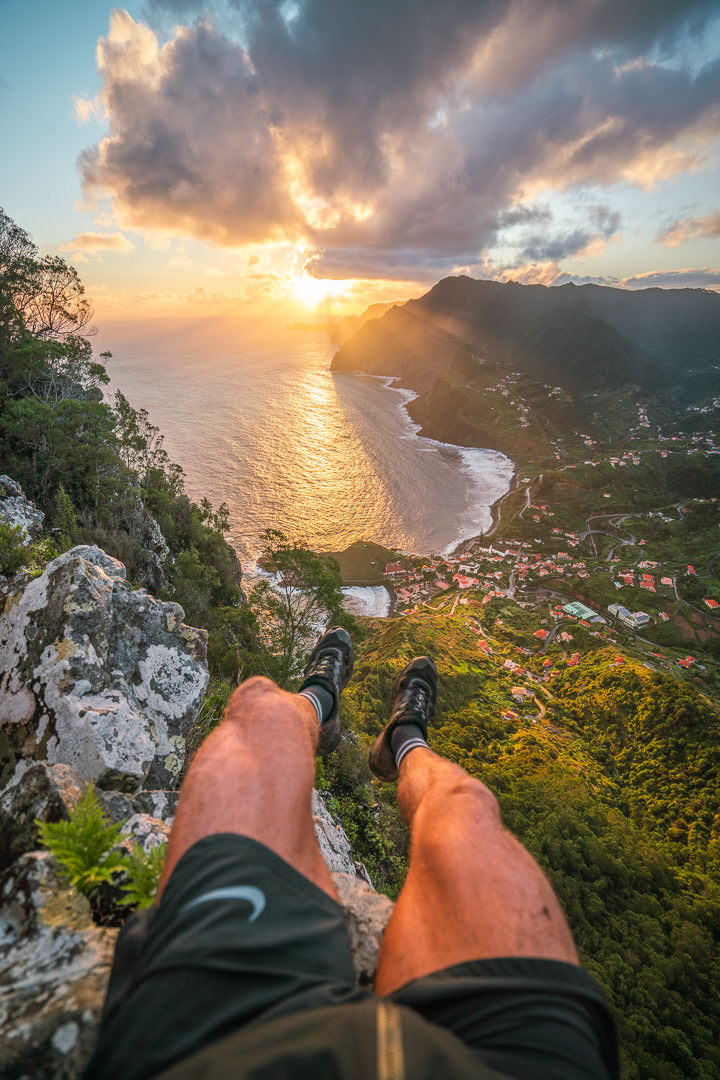
The hike up is pretty steep and will have you breathing hard first thing in the morning. You’ll need a headlamp as there are many, many opportunities to slip on uneven surfaces and natural, rocky stairs. There are no real drop-offs, which is nice for when it is dark but take care as you head up. It’s key to start early so you don’t have to rush the ascent. Once you reach the ‘top of the rock’ you will find yourself at an intersection with three trails. You want to take the middle trail. You will return to this intersection later and then you will take the trail toward Faial. The trail to the right didn’t really lead anywhere from what I found. So, head directly straight and you will have a bit of an overgrown trail for a few hundred meters before you can emerge on the cliff-side to overlook Porto da Cruz. This is the top sunrise spot on this hike in my opinion.
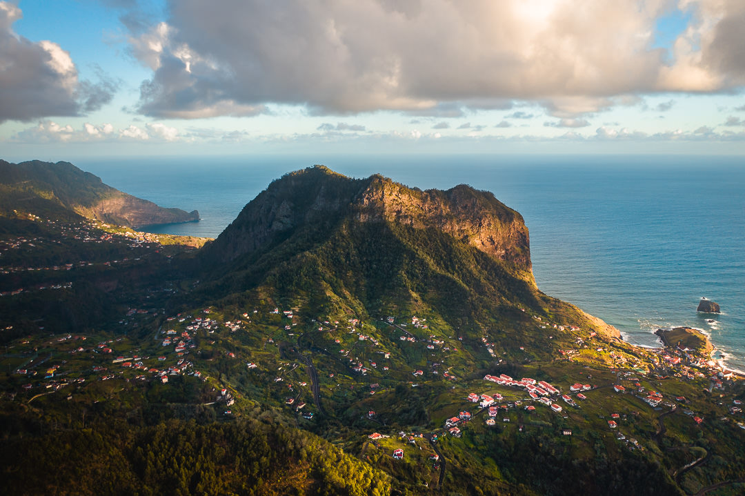
You will have an incredible view over Porto da Cruz but also along the entire east coast all the way to São Lourenço. The trail does continue further towards the coast but the viewpoint I have pictured below is about as good as it gets in my opinion.
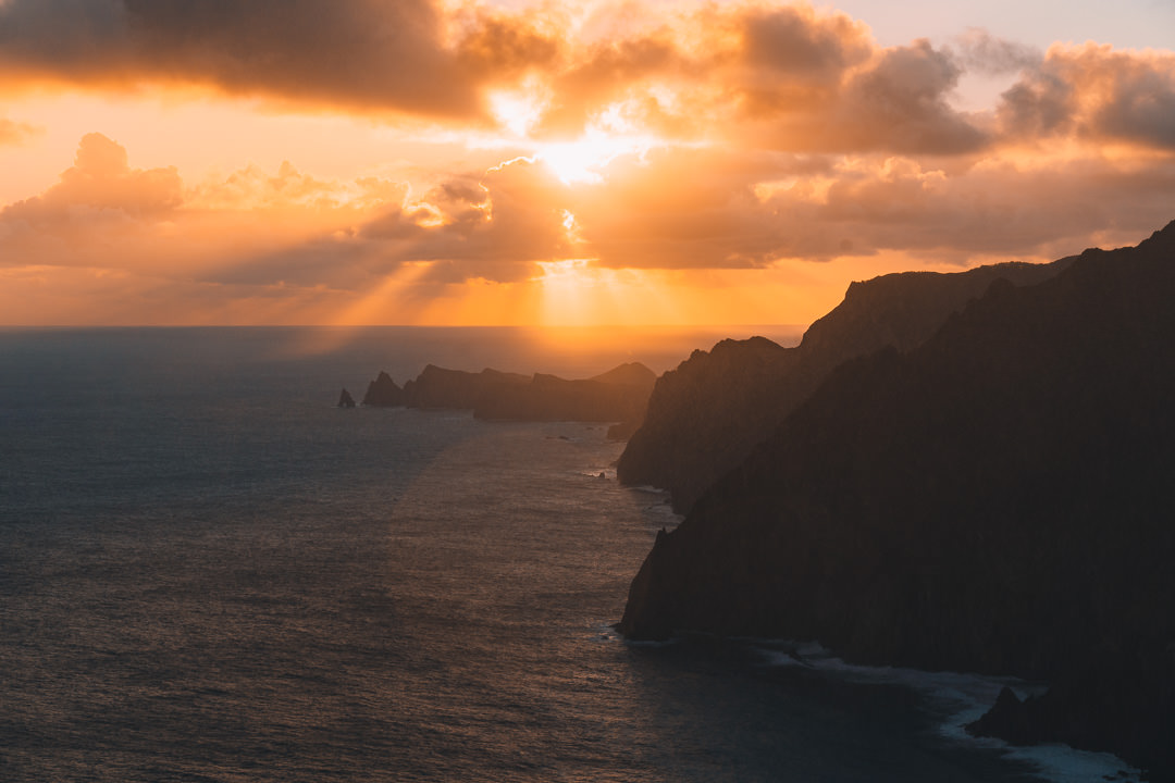


Once you have enjoyed the sunrise viewpoint over Porto da Cruz, you retrace your steps back to the intersection. You will now take the turn towards Faial (it will be on your right as you face away from the ocean). The trail leads you through the forest and down some slippery tracks. With a couple of breaks in the treeline you can get some sneaky views of the mountain ranges but this part of the hike is mostly uneventful. This next photo is from my drone but is the mountain ranges you can see.

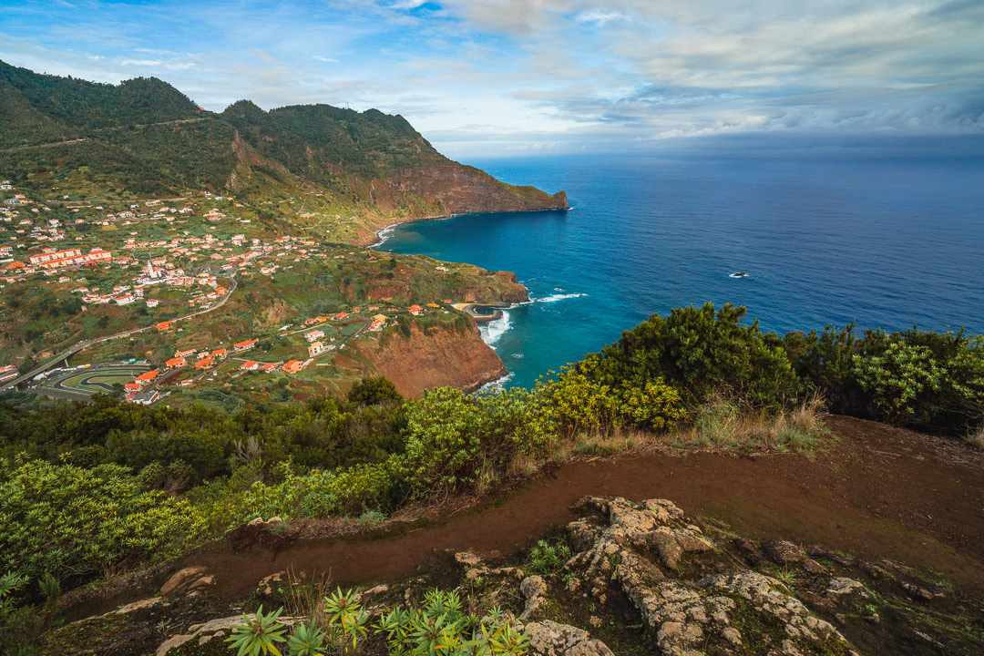
The trail leads you across the top of the rock, or over the Eagle’s Nest until you wind your way down toward the town of Faial. This is a very pretty section of trail with the morning light and makes it worth creating the entire loop rather than just going up to the Porto da Cruz sunrise spot and back down the same way.


You never actually make it into the town of Faial, the trail just drops you at the main road and you then have the decision to make. The online maps on the Madeira App tell you to take a bus but that’s a bit weird halfway through a hike. I decided to walk back. You can follow the main road although it’s a mini highway so not the safest. I used Maps.me to find an alternate route that winds through the local villages and it was actually really interesting to see all of the cultivation and farming going on in the backyards. This walk back isn’t flat with almost 300 meters of incline to top off your hike.


I hope you enjoyed this guide about the Penha de Águia hike in Porto da Cruz on Madeira Island. Happy hiking and stay safe out there.
WONDERING ABOUT WHERE TO STAY ON MADEIRA?
Throughout my six months on Madeira Island, I stayed in multiple accommodations. My favorite regions to stay in were Funchal and Canico de Baixo. I’ve created several guides to help you find the right region for you and a great hotel or apartment.
- The ultimate guide: WHERE TO STAY ON MADEIRA: WHICH REGION IS RIGHT FOR YOU?
- If you want luxury: BEST 5-STAR LUXURY HOTELS ON MADEIRA ISLAND
- To feel at home: TOP 10 BOUTIQUE HOTELS ON MADEIRA ISLAND
- If you want to base in Funchal: WHERE TO STAY IN FUNCHAL: 15 TOP-RATED HOTELS
HAVE YOU READ MY OTHER MADEIRA BLOGS?
I spent six months exploring Madeira and the nearby island of Porto Santo. These are some of my most popular guides about the region that you may be interested in.
- My favorite hikes: 65 AWESOME HIKES ON MADEIRA
- My favorite levada walks: 25 BEAUTIFUL LEVADA WALKS ON MADEIRA
- The best waterfalls on the island: 25 EPIC WATERFALLS ON MADEIRA
- Guide to the best Accommodation: WHERE TO STAY ON MADEIRA
- Hardest hike: THE MADEIRA ISLAND ULTRA TRAIL IN 4 DAYS (115KM)
- Longest hike: CAMINHO REAL 23: MADEIRA’S ROYAL PATH (180KM)