The Poio das Urtigas hike in Seixal is one of the most unique, historical hikes on the island of Madeira. This hike features a long forgotten, stone house hidden in the Laurissilva Forest. The cottage was used as a refuge during World War Two and other periods as an escape from diseases such as tuberculosis. Just as recently as a few decades ago the house was still in good shape but has dilapidated due to a lack of use and now the trail is very overgrown to reach the cottage.

Poio das Urtigas Hike details
- Hike Distance: The total distance of the hike was 11 kilometers.
- Hike Duration: The hike will take you about 5-7 hours, especially if you have a break at a few of the many scenic spots along the way.
- Hike Difficulty: This route was difficult to path find and would only be advised with a local guide or a local friend who has done the route before. Do not attempt in wet weather due to slippery drop-offs. Please don’t underestimate this route, there are many points to slip, fall and not recover. Overall, there were no climbing components but lots of scrambling and slippery terrain.
- Hike Incline: Total incline for the hike was officially 1200 meters. However, you do not need to go all the way to Fanal if you don’t want but sometimes on these steep climbs it is better to continue up and find an easier route back down.

How to get to the Poio das Urtigas trailhead
It’s best to park at Santiago Bar in Seixal and then walk west along the road until just after the tunnel where you will then turn left up the mountain. I’ve attached the parking below, which is the same parking for the Seixal Natural Pools.
My experience on the Poio das Urtigas Hike
After speaking with a few local friends over the last year or so, we set off on our mission. This trail was cleared by a few legends in the north, which would make our journey much easier than their initial ascent. However, as far as we knew, the last people on this exact route were there more than a year ago. This was evident in the overgrowth.
We drove down to Bar Santiago – Inocencia’s bar and parked the car. It was a dusty day, which often happens on Madeira when the sand ‘floats’ over from the Sahara.

We set off and quickly left behind the small, coastal village of Seixal. It’s interesting to note that the Seixal Natural Pools are right below the parking lot, so it’s a great post-hike activity to cool off… and dust off.


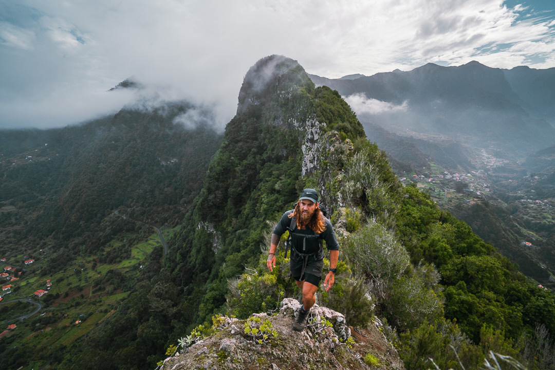
The ascent starts just after the tunnel and quickly pushes up a steep climb along the ridge. It’s crumbly and honestly, this was one of the more challenging parts of the hike. This was mainly due to not wanting to dislodge any rocks and trying our best to tread lightly and stay upright.


This early part of the route is a little tricky to remain on track given the amount of leaves that fall and cover the trail. We did our best to follow the marks although we still managed to get lost once or twice. Having a GPX route on the phone is not just handy but also a great safety precaution to avoid going down the wrong, steep paths.


The main point to note is that you need to cross the river here and then you will enjoy a small opening with a great view.
The amazing part about this trail is the history. As we scrambled up arduous slopes and steep climbs, we continuously came along the remnants of stone walls and farms. Too often we hike here on Madeira, marveling at the bravery, and determination of the farmers on this island.


After a few hundred meters of vertical gain, we reached arguably the best view of the entire hike. From our opening, we could see down into Seixal and the layered ridges of the northern coast filtered in through the hazy light.


The climb was never relaxing, the terrain continuously forced us to concentrate with leaves, fallen logs and loose stones. Often the drops down the steep cliffs of the north had us taking our time with our footing and steps.


After about five hundred meters of incline, we reached the intersection. At this point there is a path that continues up the ridge and a path that diverges to the right. We follow the path to the right for one kilometer to reach the stone cottage. Here the path becomes much more dense and the Laurissilva Forest starts to overwhelm the trail. It’s a beautiful part of the hike with ancient trees towering above us as we shuffle our way through the undergrowth.


Generally, the trail was overgrown but mostly with native plants. However, as we neared the cottage, the trail was overrun by blackberries and invasive plants. This is because the sun has more of a chance to reach these areas, which were previously terraces and gardens of the cottage.


It had been a few hours by the time we finally reached the cottage. It felt like it didn’t belong. What a journey for the occupants to make each time they wanted to go to and from the house. The stone walls are still quite well intact but the wooden interior was dilapidated. We are still searching for more solid information, but the small facts we had been told about the cottage are that it was used as a refuge from illnesses and outbreaks such as tuberculosis during periods such as World War Two. We’ve also been told that it was occupied as recently as just forty years ago in some capacity. If you have any more information feel free to add it in the comments below and I can update the post.


The view from the cottage is quite remarkable. We can see all the way down to Ilheus Ribeira da Janela. However, due to the hazy, dusty day, the view was not quite as clear as usual.

From here, you could head back down the way you came up although going down that ridge would be an interesting ride. We headed up to the foot of Fanal and then looped back down on the Cavaca trail. We had intended to follow a different ridge down but as light was fading, we stuck to a safer route that we knew was safe for low-light hiking rather than trying to a new route. It was a pretty brutal and consistent climb up with 700m climbed after the cottage with no real flat respite. Despite the route only being 11km, you will find this hike takes quite a long time due to the overgrowth and technical nature of the trail.


I hope this recount gave you a decent idea of what to expect on the trail. Please only attempt this hike with a local guide or a local friend who knows the area well.
HAVE YOU READ MY OTHER MADEIRA BLOGS?
I spent six months exploring Madeira and the nearby island of Porto Santo. These are some of my most popular guides about the region that you may be interested in.
- My favorite hikes: 65 AWESOME HIKES ON MADEIRA
- My favorite levada walks: 25 BEAUTIFUL LEVADA WALKS ON MADEIRA
- The best waterfalls on the island: 25 EPIC WATERFALLS ON MADEIRA
- Guide to the best Accommodation: WHERE TO STAY ON MADEIRA
- Hardest hike: THE MADEIRA ISLAND ULTRA TRAIL IN 4 DAYS (115KM)
- Longest hike: CAMINHO REAL 23: MADEIRA’S ROYAL PATH (180KM)