
Mount Talinis is locally known as the horn of Negros and is arguably the toughest hike on the island. Hikers can expect 1500m of incline up slippery, rocky slopes covered in tree roots and rough forest trails. The most common way to attack this challenge is by spending a night camping at one of the two lakes near the summit.

MOUNT TALINIS HIKE
There are a number of routes including an out-and-back or traversing from one side to the other. In this article, I will share with you all of the details you need to know before hiking Mount Talinis.

MOUNT TALINIS HIKE DETAILS
- Duration: The hike can be done in one day but the best way to enjoy this hike is by camping overnight at one of the two lakes near the summit. We took eight hours on day one to the summit and return to camp. The next day took us four hours to descend to the jump-off point.
- Incline: 1,425 meters from the Valencia jump-off to the summit.
- Distance: 12.8km to summit and return to camp at Lake Nailig and then 6.75 kilometers to descend to the Dauin jump-off the next morning. Total distance: 18.55km
- Difficulty: This hike would be classed as difficult for a number of reasons. Firstly, the incline is tough. 1400 meters of incline over just 12 kilometers is quite brutal and will challenge many. The other factor that makes this a huge challenge is the terrain. While 1400 meters of incline is manageable on a maintained path, this jungle track is covered in tree roots, rocks, and slippery mud. It is slow going. The last factor of difficulty is that you will be carrying your camping gear, which adds extra weight as you climb up the steep trail.

WHERE IS MOUNT TALINIS
Mount Talinis is situated in the south region of Negros near the towns Dumaguete and Dauin. There are several access points, which I will discuss below. I suggest staying either in Dauin or Dumaguete if you plan on doing this hike. I stayed in Dauin, which is a great beach/dive region that I would say is preferable rather than Dumaguete City.
GUIDES FOR MOUNT TALINIS
A guide is mandatory and there are environmental fees/permits for both the Dauin side and the Valencia side. I actually had quite a bit of trouble with a guide who did his best to rip me off with inflated fees but I now know the rough figures as of 2022. I also have the contact for my guide, Jason, who is very reliable, friendly, and a strong hiker.
Contact my guide: Jason Tilos Facebook Page

MOUNT TALINIS FEES & PERMITS(as of 2022)
- Day hike: 1500 PHP per guide for the whole group
- Overnight hike: 1000 PHP per day
- Permit Valencia: 50 PHP
- Permit Dauin: 100 PHP
- Sleeping bag rental: 150 PHP

ROUTE OPTIONS
There are a number of ways to have an adventure on Mount Talinis and you never know, which is the best until you experience it. I always love to traverse or do a point-to-point hike rather than an out-and-back so you are always on a new path. Therefore, that is what I did on Mount Talinis. I’ll explain the three main options below.
- Traverse Option: It is possible to start in Valencia on the Apolong Trail and then descend on the Bediao Trail down to Dauin. The Apolong Trail is about four kilometers longer but quite scenic with stops at the sulfur vents and several waterfall sightings along the way.The Bediao Trail passes by Yagumyum Lake but not much else. It was nice to come down the shorter route on our descent and this is the option I would recommend. This option does require you to pay for a permit in both Dauin and Valencia and potentially pay the transport fee for your guide back to Valencia.
- Valencia Apolong Trail out-and-back: This is one of the most common options and is pretty straightforward. Basically, you hike up the Apolong Trail and then camp the night before returning back down the same trail. Logistically simple. It’s probably too long to do all in one day unless you are a trail runner or a speed-hiker.
- Dauin Bediao Trail out-and-back: This is the shortest option and the main route to choose for a day-hike. While still very tough, a day hike up and down the Bediao Trail is possible. It would equate to about 15 kilometers and 1400 meters of incline on quite a technical, rocky trail. I wouldn’t suggest it unless you are very confident and would say the best way to enjoy the trail and the tranquil surroundings is to camp overnight no matter which route you choose.

DRINKING WATER ON MOUNT TALINIS
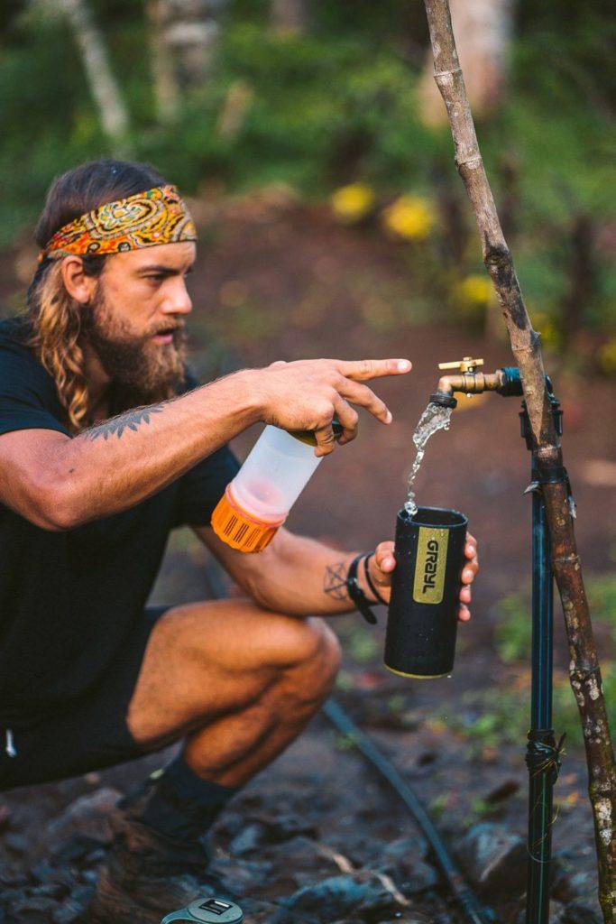
I use the Grayl Ultralight Water Purifier and it is a game-changer for hiking. The Grayl Ultralight Water Purifier removes 99.9999% of viruses of disease-causing bacteria. The best thing about it is it only takes 15 seconds and one press to purify water from any fresh water source. You don’t need to buy endless bottles or risk drinking from the two lakes.
Unlike aqua purification tablets which require you to wait 30 minutes before drinking, you can have rehydrated yourself immediately with the Grayl Ultralight Water Purifier. We filled up with this filter at the waterfalls, local pipes, and even from Lake Nailig.
GrayL Water Purifier
- Never pay for water on the trek
- Save 3-4 plastic water bottles a day
- Turns any water into drinking water

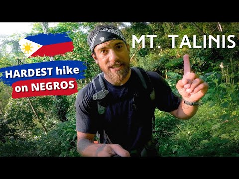
MY MOUNT TALINIS VLOG
MY EXPERIENCE ON THE LAKE NAILIG TRAIL
Our journey began in Dauin at 5:15 am when we got picked up on the motorbike. We traveled for 25 minutes to the Apolong Trailhead in Valencia. Here we met our guide, Jason, and began up the trail just as the sun began to shine through the dense forest.
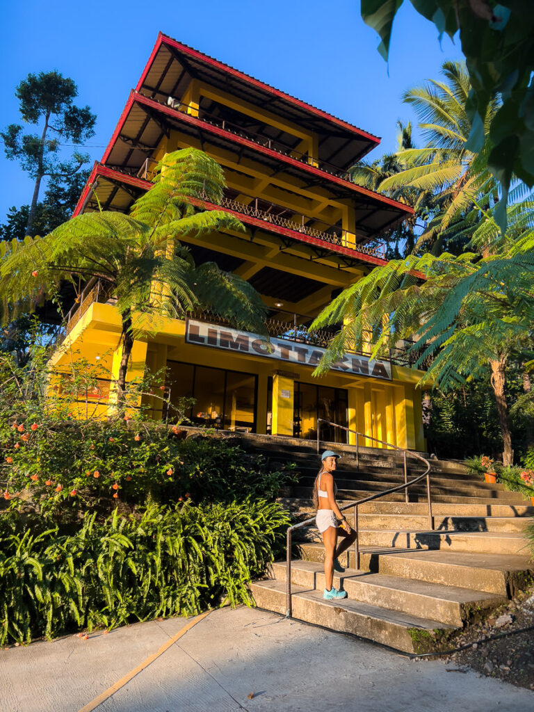
The trail actually begins at Limottakna restaurant at the trailhead but due to low visitor numbers, it was closed. This could be a good option for breakfast during the regular season.
With an entire day to summit and set up camp, we were in no rush and climbed at a steady pace through the morning. The trail passed through some local houses in the first few hundred yards before entering the wilderness. From very early on, the trail was a muddy path littered with rocks and roots that required full attention with every step. This technical nature of the path would become fatiguing for the mind aswell as the body.
The incline hits early and consistently with steep muddy stairs leading up the mountain. Our first stop was to check out Lubas falls pouring down in the distance. That would be an adventure for another day.


I thought we might be in for a hot and humid hike like many other trails in the Philippines. However, almost the entire Apolong trail is under the cover of the dense forest. This helps to keep you relatively cool for most of the day, although there were a few areas of exposure.


Our first stop was at a small watering hole just off the side of the trail. In fact, if it wasn’t for our guide pointing it out, we might have just kept on pushing forward along the trail. We stopped here for a swim to cool off in the very refreshing water. A little oasis amidst the forest.


As we continued on, we had an unexpected surprise. We bumped into Adong, who is the water guard. Basically, he manages the pipes and water flow to make sure everything is in order to supply the water back down to Valencia.
He was the first-ever Mount Talinis guide all the way back in 1976 and is still in fantastic shape. He has a small house with a vegetable garden near the pipes where he stays for fifteen days at a time before rotating with another guard.
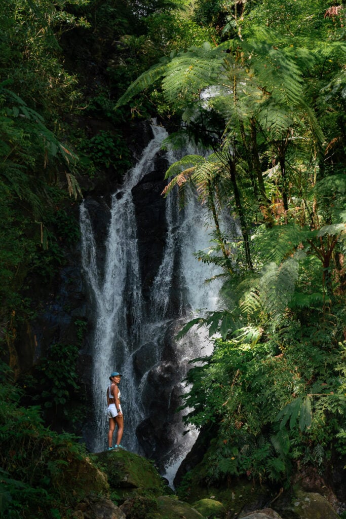
Adong offered us a coffee and some snacks with us before we headed around the corner to check out the source of the water flow, which was Twin Falls. It was an added bonus to check out such an amazing waterfall as I wasn’t expecting anything more than a hiking trail and a couple of lakes.
Our next stop was in the exposed plateau where we took a rest at a homestead. Our guide, Jason, tended to a Carabao of his nearby as we were bombarded by forty chickens while eating some snacks. Jason pulled local guava from the tree to share with us, which was beautiful!


The surprises just kept on coming as we rounded the next corner to notice a strange smell in the air. A foul odor turned out to be sulfur, which pours out of vents in the ground and runs through the river. It’s an odd spot, where the yellow river and its surroundings are lifeless. Yards away, green forests thrive in stark comparison to the dead zone around the sulfur vents.

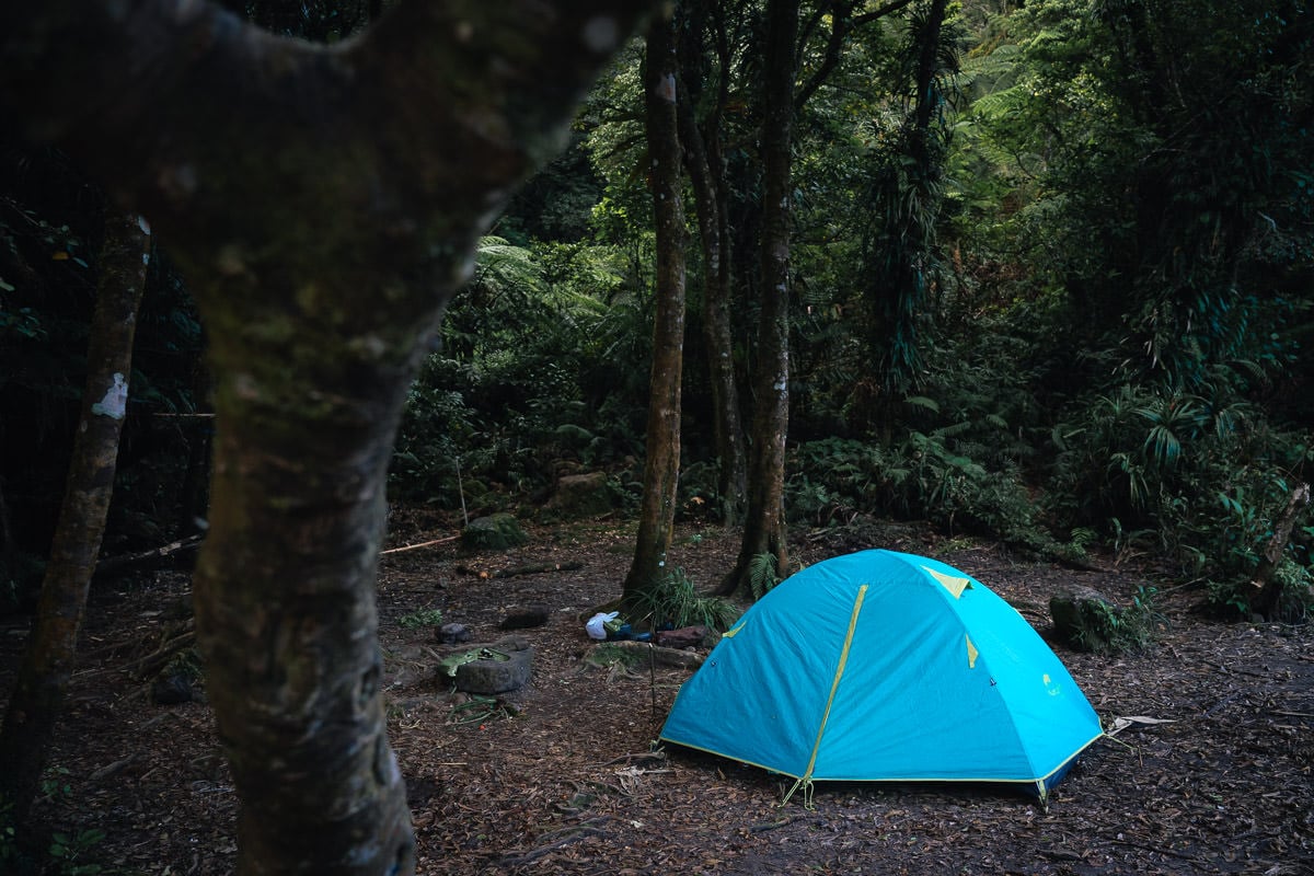
After a little more than seven hours, we reach the Lake Nailig campsite where we will spend the night. It’s a great feeling to remove the pack and know I don’t need to carry it any higher while it’s full of camping gear. The lake is stunning with forests growing right to the edge of its muddy banks creating a mystical atmosphere, especially when the fog rolls across its surface.


After setting up our tent and emptying out most of our gear, we make the final ‘summit assault’ as they like to call it here in the Philippines. It’s only 550 meters from the campsite to the summit according to the map. However, it is very steep and quite technical along this part of the trail. There’s nothing special to encounter that requires great skill but it simply takes a long time due to the awkward terrain and intertwined roots.
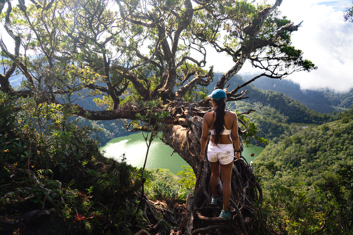
It takes us about 45 minutes to reach the summit from the campsite and I swear it must be further than 500 meters! That was a tough little climb. Atop the summit, we are the only hikers up there. The focal point of the summit is an incredible tree that arches down over the drop-off while overlooking Lake Nailig and the eastern coast of Negros.


On a clear day, you can catch views of Apo Island and Cebu. However, it is common to have cloud cover around the nearby ridges and many people actually don’t get a view at all when they reach the summit of Talinis. We counted ourselves lucky to have such a beautiful and clear view. At the summit, it wasn’t too cold as you can see but when we sat down it was nice to have a jacket as it started to get a little chilly.
The journey back down to the campsite took about 20 minutes and I was definitely glad to see those brightly colored tents as we emerged from the forest back to our camp. We cooked some noodles and headed to sleep, tired would be an understatement. I had a light sleeping bag and an ultralight down jacket, which were quite nice as it was chilly.
Our guide, Jason, said that with colder weather it can be very cold up here. Don’t skimp on warm clothes because it feels hot down by the beach. At almost 2000m of altitude, it will inevitably be cold at night.
We woke at around 7 am to see the fog rolling in over the lake, which was spectacular. We took a quick coffee before beginning the descent. It’s a slow downhill slog due to the rugged terrain. Normally six kilometers downhill could take 1.5 hours on a clear track but this descent can take 3-4 hours due to the technical terrain.
The only major point of interest on the way down is to stop at Lake Yagumyum, which is an alternate campsite for those doing the out-and-back from Dauin. To be honest, if you are doing the out-and-back from Dauin and camp at Lake Yagumyum, you really only have just over an hour or so left to reach the jump-off in Dauin so you may aswell not camp there unless you are really keen on a night out camping.

After three and half hours of descent, we made it down to the Dauin jump-off point, which is an unsigned dirt road that veers off the main road. Basically, it would be impossible to pick it. We then caught our habal-habal motorbike ride for 25 minutes back to our accommodation in Dauin to wrap up the adventure.
Overall, the Mount Talinis hike was a very challenging and rewarding adventure. Luckily, we had our campsite all to ourselves and even the summit. This made it a very peaceful journey into the wilderness of Negros.
I hope this guide helps you with the details of organizing your hike and you enjoyed the video and photos to give you an idea for what you are getting yourself into. Enjoy the adventure.
sarah
Thursday 6th of November 2025
I am looking for a guide
Nonato
Sunday 11th of February 2024
Did climb Mt Talinis via Apolong trail out Dauin it was technical ,physically exhausting & challenging.First climb to say the least but rewarding.J&J- Jason and Joey our guide and porter is the best!
Saturday 23rd of March 2024
@Nonato, planning to hike this May, do you have their contact info? Thanks in advance
Lison
Wednesday 5th of July 2023
Thanks a lot for the article, I did this (super hard) trek thanks to you ! I hiked with Jason too but here a little trigger warning to solo women travelers like me : I had to share a tent with him (I didn’t have one here) and he was too tactile, like try to hug and stuff. If you can find someone to join you, I guess it’s better
Friday 19th of July 2024
@Lison, you should have reported it to the authorities...it is so scary
Friday 13th of October 2023
@Lison, im sorry to hear this
Kristian
Sunday 30th of April 2023
Hello, really nice article. We are going to do the hike next week! Do you know where to find a guide? Or can you give a contact on your guide? Thank you so much!
Tuesday 25th of April 2023
This is very informative. Thanks! Where did you stay in Dauin? Planning on a Day-hike this weekend and we’re looking for a place to stay after the activity.