
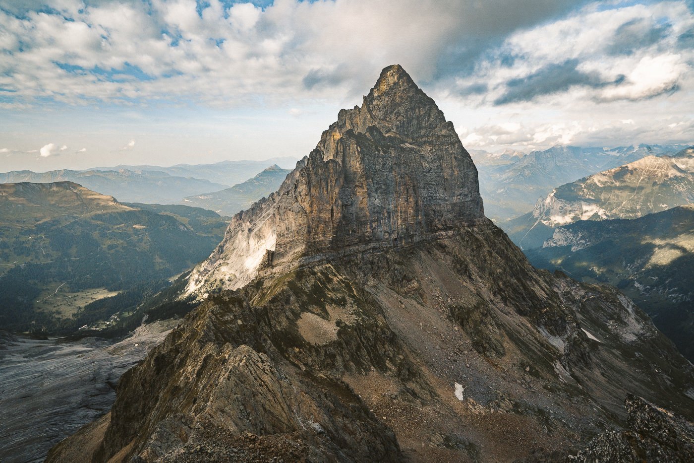
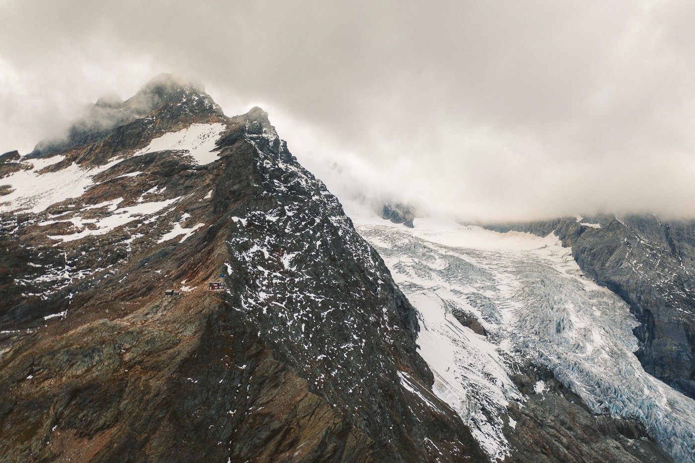
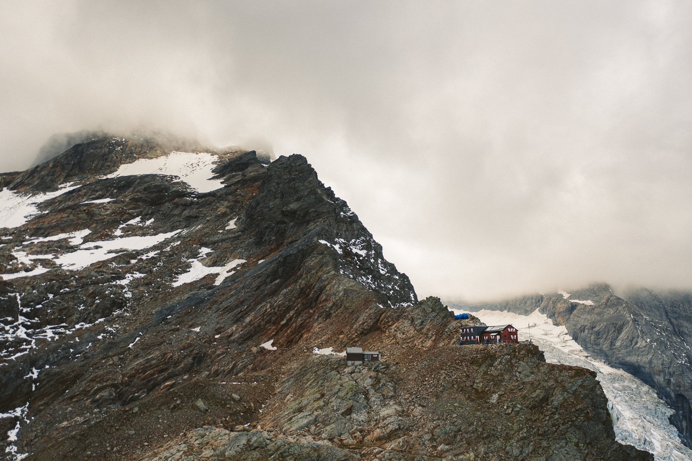
The Dossen Hut hike is an unforgettable adventure that offers breathtaking vistas and a perfect blend of dramatic landscapes. Situated in the heart of the Bernese Alps in Switzerland, this challenging trail starts from Rosenlaui glacier gorge and takes you on an incredible journey to the Dossen Hut. The Hut, located at an impressive altitude of 2662 meters, is a warm and hospitable mountain refuge. As you ascend through the scenic trail, you will be enchanted by the mesmerizing sight of rugged glaciers, lush green valleys, and diverse Alpine flora and fauna. From the Hut, you can enjoy panoramic views of majestic peaks such as the Wellhorn, Wetterhorn, and Rosenlaui Glacier. The Dossen Hut hike is an unforgettable experience and a true test of one’s spirit, making it an absolute must-do for any seasoned hiker visiting Switzerland.
DOSSEN HUT HIKE: COMPLETE GUIDE
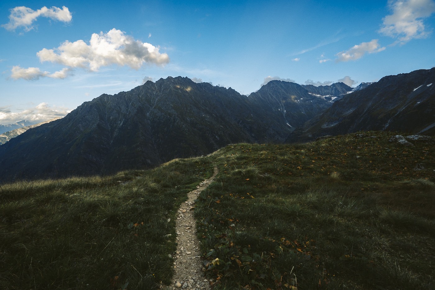
The Dossen Hut hike is an epic 19km T4 Difficulty route that starts off at Rosenlaui Glacier, and leads you up to the mountain hut and down to Innertkirchen.
DOSSEN HUT HIKE DETAILS
- Hike Distance: The hike from Rosenlaui Hotel to Dossen Hut is just over 5km but the entire route takes 19km to end you at Innertkirchen.
- Hike Duration: The suggested duration is about 8 hours from Rosenlaui Hotel to Dossen Hut and down to Innertkirchen. However, as you will see in this blog post, I did the hike in 5 hours but also had to run an extra 5km from Innertkirchen to Meiringen Train Station. So it is possible in less than 5 hours but likely it will take 5-10 hours for most hikers.
- Hike Difficulty: The path is a blue and white alpine rating and has a number of exposed areas. There is cable and ladders wherever the trail is exposed. I’ve captured the T4 difficulty in my vlog below so you can see the technical moments. 1200m of incline to the hut from Rosenlaui Hotel is something many would consider difficult but after that, it is mostly downhill.
- Hike Incline: Starting point at Hotel Rosenlaui: 1,356m – Dossen Hut: 2,663m – Innerkirchen: 630m
HOW TO GET TO DOSSEN HUT HIKE TRAILHEAD
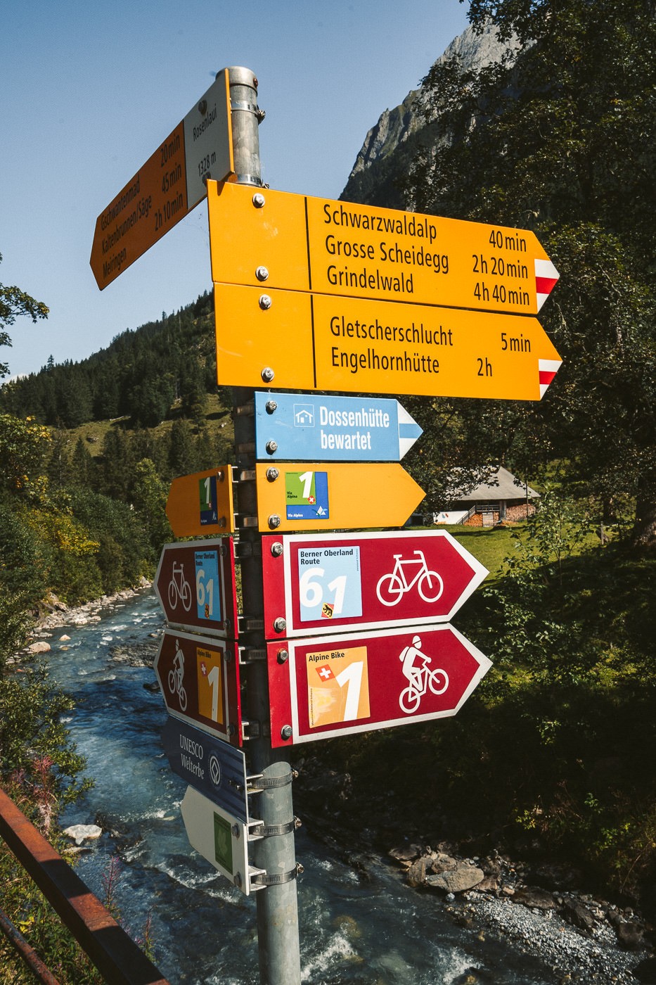
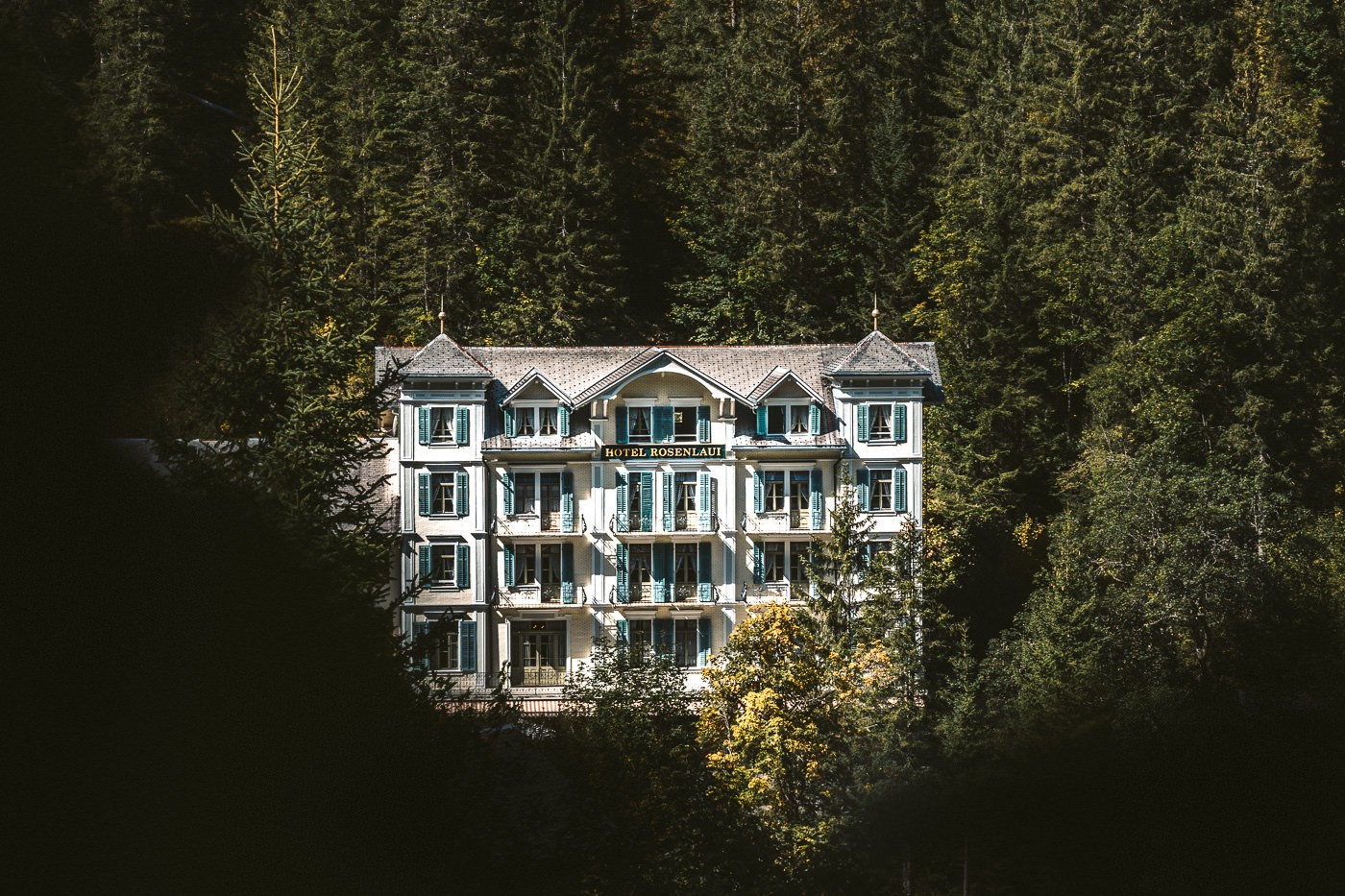
The starting point for the Dossen Hut hike is the Rosenlaui Hotel. To get here you will need to take the train to Meiringen, then transfer to the bus and head to Rosenlaui Hotel bus stop. The bus will drop you directly at the front of the hotel and you then have blue and white signs pointing you to ‘Dossen SAC’ the whole way.
You could also drive to Rosenlaui Hotel with ample parking available. Whichever way you plan to get there, just know your starting point is Rosenlaui Hotel.
I’ve attached my GPX map below, which you can download here for use on your Garmin, smartwatch or another app.
GET A SWISS TRAVEL PASS!


Enjoy UNLIMITED train, boat, and bus rides in Switzerland for up to 15 days. Click to book a flex Swiss Travel Pass or choose the Consecutive Swiss Travel Pass.
The Swiss Travel Pass starts at $260 for 3 days. Click here to check if it’s available on your travel dates.
HOW TO BOOK A NIGHT AT DOSSEN HUT
In order to book a night (or more) at Dossen Hut, you will need to send an email, make a phone call or fill out the form on their website. They are not on other booking platforms, this is how the hut is booked.
- To email Dossen Hut, you can contact them here: [email protected]
- To visit the website to make a booking you can do so here: www.dossenhuette.ch/
- To make a booking via phone you can do so with this number: +41 (0) 33 971 44 94

MY DOSSEN HUT HIKE VLOG
While I still took lots of photos, on this hike I put my efforts into documenting the hike through this vlog. That means that in the T4 sections and lots of the downhill running, the best viewing is in the vlog rather than the photos. It’s definitely worth a watch to see how the hike ended in the dark for me. You will soon see how I did the 24km route in 5 hours!
MY EXPERIENCE HIKING TO DOSSEN HUT
My day began in Interlaken so I caught the train to Meiringen and then transferred to a bus that took me up to Rosenlaui Glacier Hotel. The hike was signed from this point on with the blue and white Dossen tags. The Rosenlaui Hotel is a popular base for lots of hikes in the region and you can get lunch or have a toilet stop here.
ROSENLAUI GLACIER HIKE
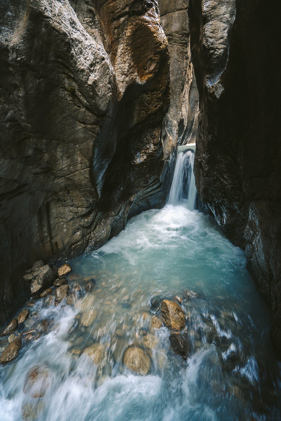
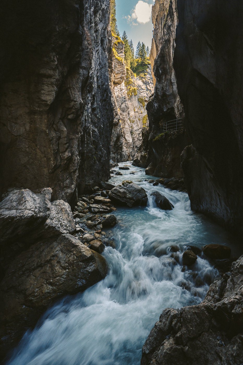
I didn’t know it at the time but before I hiked up to Dossen Hut, I would head through and explore Rosenlaui Glacier Canyon. It turned out to be super cool and is more or less part of the trail anyway. It costs $7 to enter the canyon or you can walk around it and meet the trail at the top. I think it’s worth heading in for a look although it is just 15-20 minutes worth of path.

The canyon has been created through millions of years of erosion from the glacier and subsequent river. When you are inside it becomes so much colder than outside and the spray from the waterfalls is blowing around. It’s a crazy section of the hike although the trail is cement with simple stairs and handrails making it very safe.
ROSENLAUI TO DOSSEN HUT HIKE
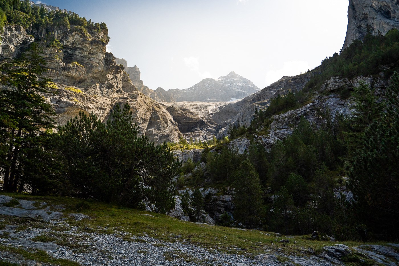
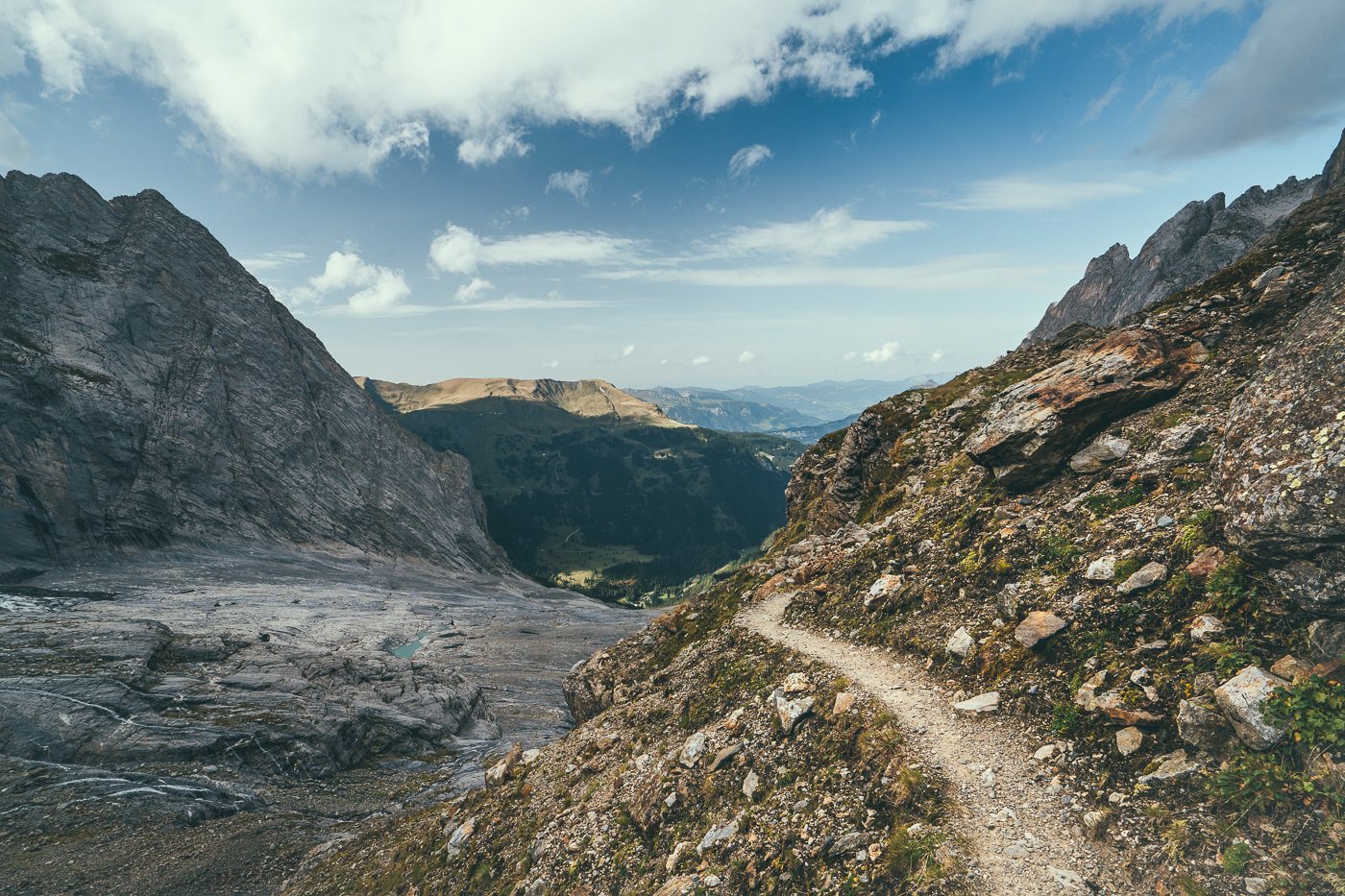
The trail spits you out of the canyon and meets up with the alternative route if you did decide to skip the canyon glacier. Now the trail sends you on a decent climb through the forest where if it’s sunny you will have no wind and be sweating a lot! I pushed pretty hard through this section until I emerged at the river, where I could see all the way up to Dossen Peak. Lots of people climb either Dossengrat or Dossen Peak but on this day, I was only heading to the Dossen Hut, which is still over 2600m above sea level.
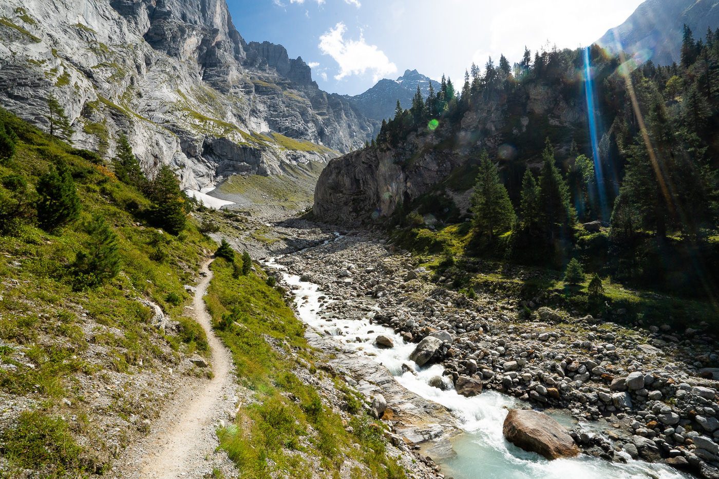
The trail now runs alongside the river before ascending through the gravel and rocks on the left of the trail. Here I met some Valais Sheep who you can see in my vlog above. This gravel section is consistently steep but not exposed until the trail leads you up onto a ridge. Take caution here as the drop is quite exposed.
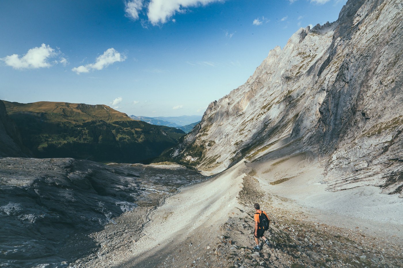
Once at the top of the ridge, you can look back along the valley you have just hiked with a small sense of achievement. You are only halfway to the hut at this point with a lot of bouldering and climbing to go. This is where the T4 difficulty kicks in with some ladders, cables and relatively easy bouldering required. Again, you can check out some pretty cool videos in the vlog of this section to check if you are up for the challenge of deciding it isn’t a hike you are ready for.
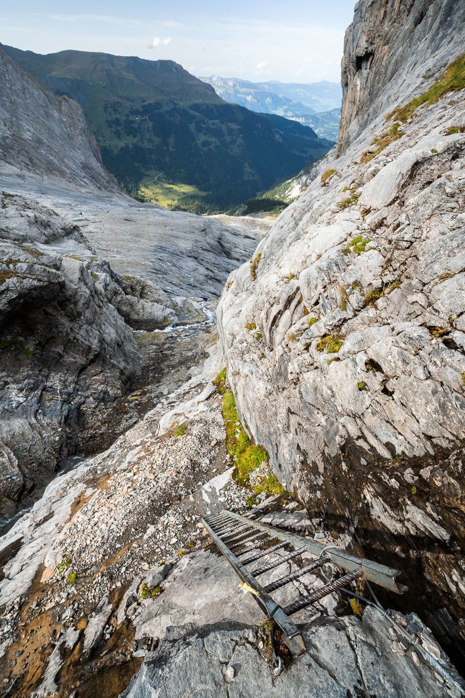
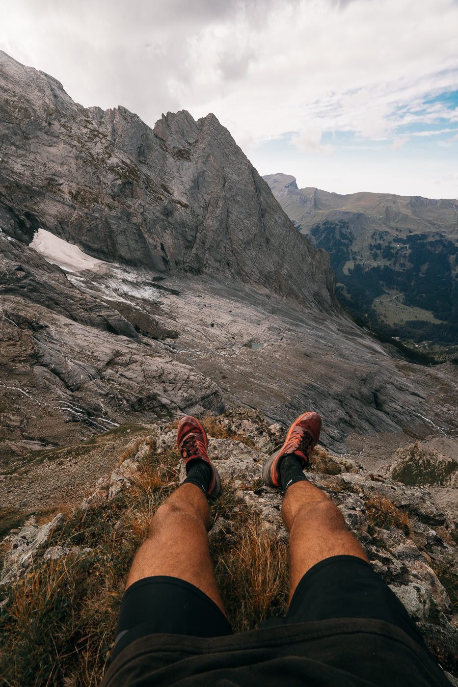
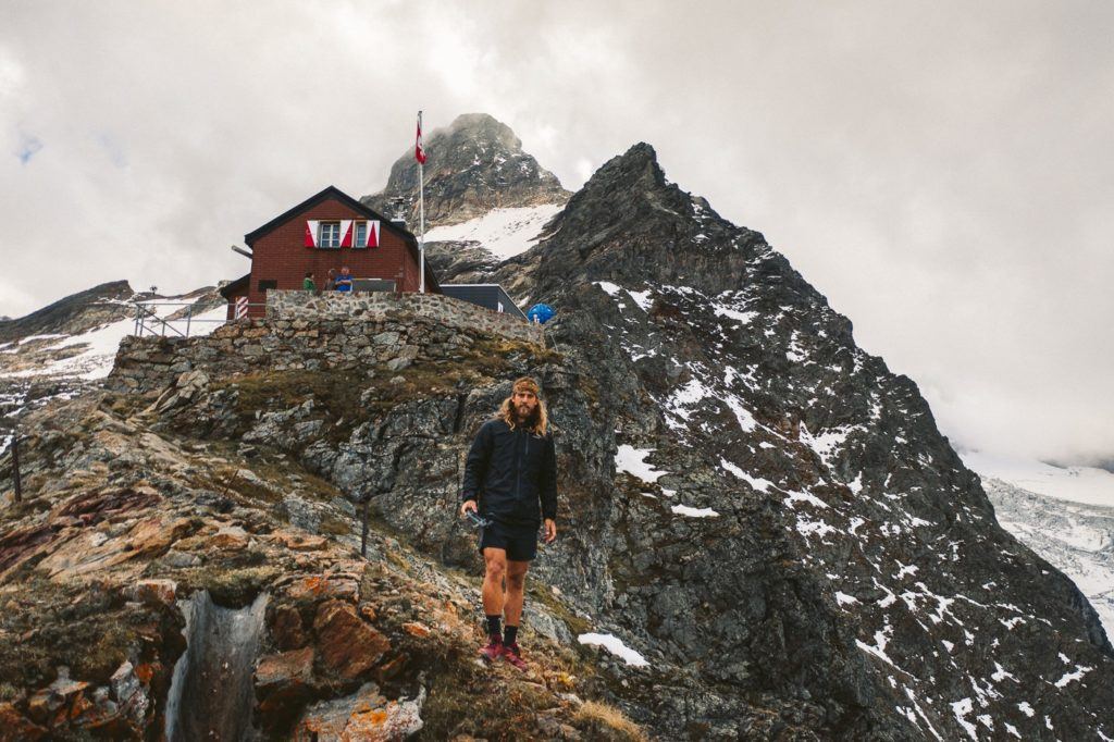
I found that this section of the trail was the most fun as you had to consistently find your way up the boulders looking for the next blue and white painted marker. The views got better and better as you climbed up with the glacier now in full view. After 1 hour and 47 minutes, I reached the Dossen Hut and took a moment outside to enjoy the views before flying the drone over to the glacier and around the mountain hut. They serve their coffee in bowls at the Dossen Hut, that’s how coffee should be!
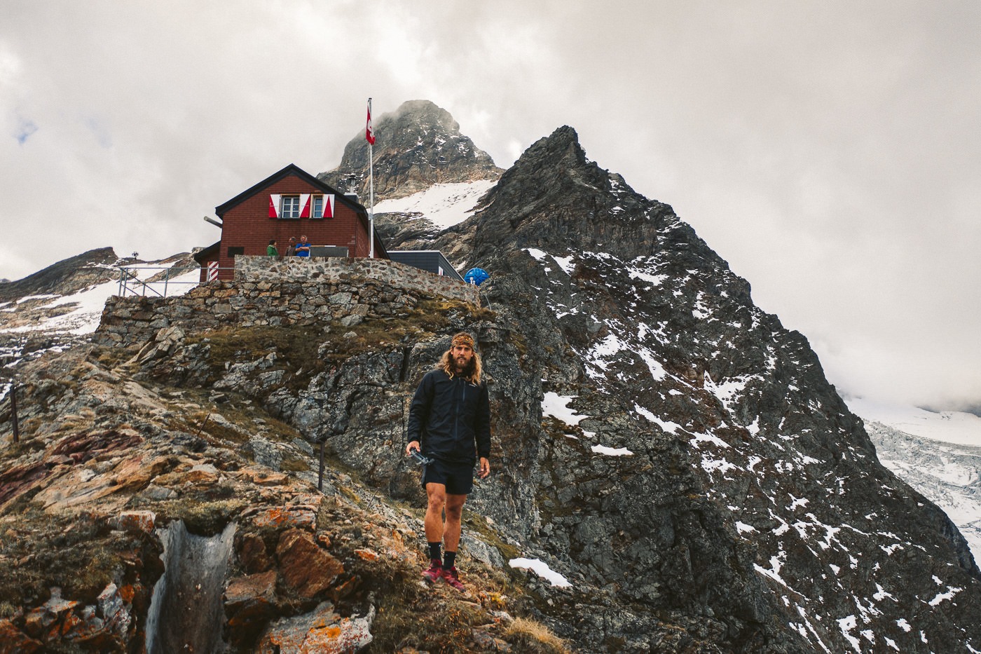

I arrived at the hut at around 5:30 pm and they were very concerned that I was hiking down and kept telling me I need to hurry up and leave. I had my headtorch and knew I was in for a session but their concern was genuine.
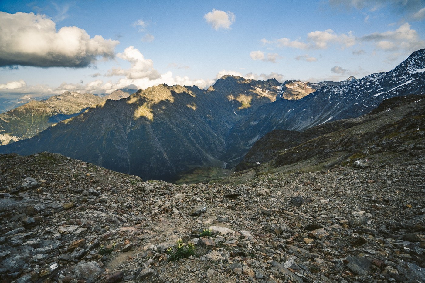
After my coffee, drone session, and panoramic view, I packed up and began to run down the mountain (refer to vlog). It was apparently meant to take 4 hours and 50 minutes to Innertkirchen, with about 14km left on my journey and just 2 hours of daylight.
The trail down was gravel and I slid and ran my way down the slopes before it leveled out a bit. I ended up doing more than 2000m of decline on the way down as Inertkirchen is only 630m above sea level.
About halfway to Innertkirchen, it became dark and I had to run through the valley with just my headtorch. It was definitely an adventure! You could avoid that by starting earlier in the morning. The last train from Innertkirchen was at 9 pm, which I missed by half an hour so I had to run another 4.5 km to Meiringen to luckily catch the last train back to Interlaken.
Make sure you check the train timetables so you know what you are working with time-wise. Some people also pre-book a taxi to pick them up at the end of the trail but I found you can just walk all the way to Innertkirchen train station rather than booking a taxi, which is a bit unnecessary for a few kilometers when you have already hiked 15km or so.
Staying at the hut overnight would rule out all of the hassles and mean you could enjoy a beautiful sunset, dinner, breakfast, and sunrise at the Dossen Hut.
THINGS TO KNOW ABOUT DOSSEN HUT
Eco-friendly Refuge: The Dossen Hut is known for its commitment to sustainability. It runs entirely on solar energy and uses a sophisticated system for wastewater purification, standing as an example of how human habitation can harmoniously coexist with nature, even in such challenging environments.
Climbing Routes: The Dossen Hut serves as a base for climbing the Dossenhorn, a peak that stands at 3,143 meters. It offers various climbing routes, including some on the Rosenlaui Glacier. This makes it an important destination for mountaineers seeking to conquer the Bernese Alps’ more challenging routes.
Historic Significance: The Dossen Hut has a long history, having been established in 1910 by the Swiss Alpine Club. Despite modern renovations, the hut still retains a sense of the past, providing a rustic and traditional Swiss mountain refuge experience, creating a unique blend of history and comfort for visitors.

SWISS TRAVEL PASS or HALF-FARE CARD
OPTION 1: Buy the Swiss Half Fare Card: Switzerland trains, buses, and cable cars are EXPENSIVE! I found the best way to get around cheaply was to buy the Swiss Half-Fare Card before I arrived. It gives you 50% off every regular train, bus, and even many cable cars. It only costs $150 USD but pays itself off in just a few days with many train tickets in Switzerland costing close to $100 alone. If you are staying for more than 5 days, I suggest buying the Swiss Half-Fare Card.
OPTION 2: Buy the Swiss Travel Pass: The second option is to get the Swiss Travel Pass, which gives you unlimited train, bus, and (many) cable car rides but it’s pretty expensive at around $100 USD per day so if you don’t travel each day it isn’t worth it.
OPTION 3: Buy the FLEXI Swiss Travel Pass: The final (BEST) option is to get the FLEXI Swiss Travel Pass, which allows you to buy 8 days’ worth of transit but you can choose the night before if you want to activate the next day. That way you don’t need to travel every day to get your money’s worth, you can just activate the FLEXI Swiss Travel Pass on the days when you are doing sizeable transits. My advice is to book the Swiss Half-Fare Card or the FLEXI Swiss Travel Pass in advance before your trip so it’s ready to go when you arrive.
GET A SWISS TRAVEL PASS!
Enjoy UNLIMITED train, boat, and bus rides in Switzerland for up to 15 days. Click to book a flex Swiss Travel Pass or choose the Consecutive Swiss Travel Pass.
The Swiss Travel Pass starts at $260 for 3 days. Click here to check if it’s available on your travel dates.
MY SWITZERLAND HIKING GUIDES
I spent 100 days hiking in Switzerland and created a guide for different regions around the country. You can click on one of my Switzerland hiking guides below to help you plan your trip.
- The Complete Guide: 50 AWESOME HIKES IN IN SWITZERLAND
- The Via Ferrata Guide: 4 EPIC SWITZERLAND VIA FERRATA COURSES
- Lauterbrunnen Guide: 10 AWESOME HIKES NEAR LAUTERBRUNNEN
- Interlaken Guide: 15 AWESOME HIKES IN INTERLAKEN
- Grindelwald Guide: 12 AWESOME HIKES NEAR GRINDELWALD:
- Mürren Guide: 7 AWESOME HIKES IN MURREN
- Appenzell Guide: 9 AWESOME HIKES NEAR APPENZELL
- Chur Guide: 7 AWESOME HIKES NEAR CHUR

MY SWITZERLAND TRAVEL TIPS
- For Backpackers: SWITZERLAND BUDGET BACKPACKING GUIDE
- Travel Tips: 20 THINGS TO KNOW BEFORE VISITING SWITZERLAND
- Transport Tips: RENTING AND DRIVING A CAR IN SWITZERLAND
- Accommodation Guide: 30 BEST PLACES TO STAY IN SWITZERLAND

Cece
Sunday 7th of August 2022
That was an amazing hike Jackson!!
Thanks a lot for you so well explained hike details. I got inspired through your blog and decided to do this hike with my boyfriend. I'd say that we are intermediate hikers. Our total time to go up was 2 hours and 50 minutes. We decided to stay at the Hütte because why not live the new experience, meet other hikers and see the sunset and sunrise and it was totally worth it! the view was breathtaking and everyone in the hut was super nice.
We took the same route back to Innertkirchen, which took us around 5 hours to complete because it had just rained and the road was a bit slippery. I must say that my knees hurt a bit from the way down but I'd do this again!
Regarding the guy below, I believe that each one of us is responsible for our actions and if we choose to take this hike (which you clearly explained that it is not easy) it is because we feel prepared to do it.
Once again thanks a lot! Your blog rocks and keep doing what you are doing :)
Jackson
Tuesday 6th of September 2022
Thanks mate
Vitor
Thursday 24th of September 2020
Jackson, good and positive vibes only, remember ;) I think we are a little like-minded in that aspect...
Whether you accept it or not, you are also responsible for your blog posts, as I am for my comments. I did what I had to do as I felt responsible for your future readers of this entry to have a "maybe" more realistic description of what this hike involves - you seem to dismiss a little how challenging this can be for regular hikers who might read your post.
It can be done? Of course. I did it. Ideal? Well, you loose a lot on the way down because you're rushing, and you can't take in the views that well because you're also rushing and it's getting dark... and you can get lost and injured because... well, you're rushing and gps signal failure... But of course it can be done....
Listen, you have my email. As far as I am aware, this issue is now in the past. I get your position, but I have mine too. Let's stop this here, please.
And enjoy Madeira!!! It's such a great place with so much to offer, and very dear to me too ;)
Honestly, I do hope we cross paths sometime or share a journey at some point. To be frank, I think we would quickly move past this "misunderstanding" and quickly focus on the more pleasurable and exciting task of enjoying the hikes instead. Take care, and make the most of this journey ;)
Jackson
Sunday 27th of September 2020
I accept responsibility for my blog posts. I give as much information as I can. That doesn't mean I am responsible for how you interpret that and also how you or others hike or act on the trail. There is a big difference. I can't tell every single hiker how hard it can be for them personally without knowing them. So i show photos of difficult sections, put my maps, put my time, suggest a time for average hikers etc. etc. like no other blog or video about this hike. You then need to analyze and figure out for yourself what is possible. You never answered about why it took you 5 hours to get to Dossen Hut, which is 5km but this is probably why you ran late. I said to allow for 8 hours but that assumes you are moving at AT LEAST a pace of 2.5-kilometers per hour, which is FAR below an average hiking pace. That's my logic and after reviewing the information in this post that I've provided, I'm confident I have shown enough details for people to make a decision based on their own. Regards, Jackson
Vitor
Tuesday 22nd of September 2020
Hi Jackson, First of all, great work you have done here. It's an amazing work with all these hikes, particularly in Interlaken, which is where I have been recently...
However, and take it easy when you read this, but you publishing this one was a bit reckless on your side - it should come with big red warning letters warning people that IT IS NOT an easy hike at all. Even the video should have that warning often. And people should do it in two days, not one...
Now, don't get me wrong. This is a great hike - but for inexperienced people, people who like to think they are better than everyone, or even those that don't fully read your post or skip your video on it, it's a risk. A great risk. And the possibility of GPS signal failure may make this a tragic activity.
I reached the Dossen hut at 3-4pm (having started the hike around 11am at the Rosenlaui hotel), and started going down walking around 4pm (I figured "screw that, there's daylight until 9pm). It was an awesome bright and blue-sky day. The journey down, gets a little "challenging" at a point when you reach a place where they keep the cows.
I am not into running, and unlike you, I wasn't going to sprint (I like my knees). There were some parts where your gpx trail was taking me to places that didn't offered much and away from the main trail I thought (this past the cow hut, and close to a stream/river) - at one point I was going down the river side as there was no clear path to follow, and thinking to myself that there was no way I was on the right path. GPS signal failure was an issue, and being in an area with poor network coverage didn't help - now, I didn't get scared, but when I see myself still kilometres away from Innertkirchen on the map in the phone, getting dark, and suspecting that I was getting off track without signal, I did get anxious... I checked the GPX signal several times and went back to where I fell "safer", wasting up to 45minutes with this, at a moment of reducing daylight and looking to the GPX trail and thinking that there was still a long way to go, of several kilometers, to get to Innertkirchen train station or Meiringen walking....
Eventually, I got onto the right path again, and was able to reach Urbachtal parkplatz around 9pm, just about to get dark.
Now, at that time, you're still asking for a 6km walk to Innertkirchen, but realistically, twice that to get to Meiringen as you would have missed the last train in Innertkirchen (this for someone who wants to just walk, not running).
For any "normal" person after a long day of hiking it is just tooo much, and I would have never arrived to the train in Innertkirchen or Meiringen on time had I not relied on a taxi to take me there. This was also a fun moment, because when I first called, I got nowhere with the taxi person - he only spoke German, and did not understood any English. I was lucky someone parked at Urbachtal parkplatz was kind enough to call them and speak to the taxi guy in German for me, but others may not be as lucky....
Well, it was a great day, and an awesome hike. But please, fill it up with prominent warning signs that it is a risky hike for being soooo long....
Don't think I am telling you off. You really have done an amazing job with this website, and you should think about maybe put it on a book. Have you also considered one post about all the gear you have used to take the photos and what photo imaging software you've used?
I look forward to do some more of your suggestions posted here at a later time ;)
Jackson
Tuesday 22nd of September 2020
Hey mate,
Glad you are enjoying my hiking guides :) I don't take anything personally but I will share with you why my guide is not reckless but not following my advice in the guides will lead to you going out on a reckless adventure. I gave many tips that you haven't followed here so that you could avoid my rushed run home. The main one was to start early in the morning which you didn't do and subsequently missed the last train.
Why did it take you 5 hours to reach Dossen Hut if you started at 11am and only reached the hut at 4pm? It's only a 5-kilometer section?
I stated that it is (in general) an 8-hour trip so starting at 11am is an indication that you plan to finish at 7pm at the earliest if everything goes well. That is assuming a 2 or 3-kilometer per hour pace.
I can't do much else than quite clearly provide all the details of my own journey but also how long it might take others. With all due respect you need to take responsibility for your own speed, own route, own hydration and own capabilities. When I did the hike, no-one provides me with a detailed blog post of the step-by-step guide, which bus to catch, how many liters of water to take. I provide my readers with as much information as I can but at the end of the day.. if they pack only two water bottles on a hot day for the Hardergrat hike it ain't going to be my fault that they are thirsty. Or if someone doesn't want to trail run because they are running late on their schedule they should have left earlier than 11 am so they can get the last train. I literally wrote in the blog 'you could avoid that by starting earlier' yet you only began at 11am. I gave the advice of how to avoid but you still started just before midday.
I really go into so much detail with distances, difficulty, creating maps based on my exact GPS coordinates etc... only so much I can do other than to walk beside someone as a guide. I have to find out everything as I go with almost no tips for most of these hikes. I simply use Maps.me with no recommendations prior to the hike. Google Dossenhut and many other hikes and you will see no other blogs or a very basic overview. And I did leave Dossen Hut at 5pm... The hut warden asked if I'm sure but even he wasn't that worried. Life is an adventure.. if you miss the last train, you will figure it out. If you run you might catch it if you don't miss it. Not everything has to go to plan. If you don't want to run, leave earlier right haha?